
How Much Does Ground Penetrating Radar Cost?
Updated on | Researched and reviewed by Alec Pow, Founder & Pricing Investigator
Prices, claims, and calculations checked against 16 cited sources. See our research methodology and corrections policy.
A new professional ground penetrating radar system typically costs about $14,000 to $35,000 for the single-channel utility-locating and general-purpose equipment most contractors encounter. More advanced multi-frequency, multi-channel, 3D, vehicle-mounted, or specialized geophysical systems can cost $40,000 to more than $100,000.
Used professional GPR systems commonly sell for about $4,500 to $13,000, while renting can cost roughly $165 to $380 per day for many conventional cart-based systems before setup, mobilization, shipping, or insurance.
If you only need one survey, hiring a trained GPR crew is usually much cheaper than buying the equipment. Current industry estimates put professional GPR surveys around $1,000 to $5,000 per day, depending on the application, site, reporting requirements, and equipment.
Ground penetrating radar, or GPR, sends electromagnetic energy into the ground, concrete, pavement, or another material and measures reflections caused by changes in electrical properties. It is used for utility locating, concrete scanning, void detection, archaeology, environmental investigations, roads, bridges, cemeteries, geology, and subsurface mapping.
Article Highlights
Jump to sections
- Most new professional single-channel GPR systems cost approximately $14,000 to $35,000.
- Advanced 3D or multi-channel arrays can cost $100,000+.
- Current used systems can be found around $4,500 to $13,000.
- Common GPR rentals currently run around $165 to $380 per day, plus setup or mobilization charges.
- Hiring a GPR survey crew commonly costs around $1,000 to $5,000 per day.
- Modern GPR systems often include the controller, display, battery, survey wheel, and basic acquisition software, so a separate laptop is not automatically required.
- Antenna frequency should be chosen for the job: higher frequencies provide greater resolution but generally less penetration.

How Much Does Ground Penetrating Radar Cost?
A useful 2026 price breakdown looks like this:
| GPR Option | Typical Cost |
|---|---|
| Used/refurbished professional system | $4,500–$13,000 |
| New entry/professional utility GPR | $14,000–$25,000 |
| Higher-end single-channel / multi-frequency GPR | $25,000–$40,000+ |
| Advanced 3D / multi-channel array | $40,000–$100,000+ |
| Rental | $165–$380/day |
| Professional survey service | $1,000–$5,000/day |
| Operator training | About $350–$1,400+ per person |
The enormous price spread exists because a handheld concrete scanner and a 30-channel 3D mapping array are both called GPR even though they are designed for completely different work.
Current New GPR Prices
US Radar’s published equipment-cost guidance puts the entry point for new professional GPR systems at approximately $14,000, with better-equipped configurations commonly reaching $25,000 to $35,000.
A current dealer lists a GSSI UtilityScan Pro at $14,500. That package includes the control unit, antenna, cart, and warranty and is designed specifically for underground utility mapping and locating.
Public-sector purchasing also provides a useful reality check. One California water district’s FY2027 capital budget currently allocates $30,500 for ground penetrating radar equipment.
Those examples support approximately $14,000 to $35,000 as a realistic range for professional systems without implying that every GPR machine costs the same amount.
High-End 3D GPR Systems
The market extends far beyond ordinary utility carts.
Modern 3D systems can use multiple antenna channels to collect many parallel radar lines in one pass.
A current MALÅ GPR equipment catalog, for example, lists the MALÅ Easy Locator Core, WideRange systems, airborne GPR units, and the much more sophisticated MALÅ MIRA Compact.
The MIRA Compact can contain as many as 30 channels for high-speed 3D mapping.
Current industry analysis consequently places sophisticated multi-channel and vehicle-mounted systems above $100,000.
These systems are used for work such as:
- Large utility corridors
- Road networks
- Archaeological mapping
- Infrastructure surveys
- High-speed 3D subsurface mapping
They should not be compared directly with a basic push-cart utility locator.
Used GPR Cost
Buying used can cut the purchase price dramatically.
Current professional-equipment listings include:
- Used GSSI SIR 3000 system: about $4,500
- Used GSSI UtilityScan LT: about $5,800
- Used StructureScan Mini XT: about $6,000–$6,600
- Used GSSI UtilityScan: about $7,500
- Used GSSI SIR 4000: about $7,500–$8,900
For example, one current dealer lists a serviced GSSI SIR 3000 package for $4,500, including a 400 MHz antenna, RADAN software, batteries, charger, and transport case.
Another current used-equipment marketplace shows professional GPR systems around $5,350 to $13,900, depending on model and application.
Before buying used, verify:
- Battery condition
- Antenna condition
- Calibration
- Software license transfer
- Controller/tablet compatibility
- Firmware support
- Cart and encoder condition
- Manufacturer service availability
A cheap antenna without a compatible controller or transferable software license may not be a usable bargain.
GPR Rental Cost
Renting makes much more sense for occasional work.
One specialized U.S. rental provider currently lists:
- LMX200 SmartCart: $165/day
- Noggin 250/500/1000 SmartCart: $165/day
- pulseEKKO system: $300/day
- 100 MHz ultra/deep system: $380/day
The published GPR rental rates also show monthly charges of roughly $3,960 to $6,900 depending on the system.
Another equipment company currently rents a GSSI UtilityScan for $225 per day, with a $180 preparation fee and a stated replacement value of $19,000.
That means a one-day rental could effectively cost:
$225 rental + $180 preparation = $405
before shipping or insurance.
For a one-off project, that is far cheaper than buying a $15,000 to $30,000 instrument.
Hiring a GPR Company
The cheapest solution can be hiring someone who already owns and understands the equipment.
A current 2026 GPR cost analysis places professional field surveys at approximately $1,000 to $5,000 per day.
The project price can depend on:
- Survey area
- Utility density
- Grid spacing
- Required depth
- Concrete versus soil
- 2D versus 3D work
- GPS requirements
- Number of operators
- Data processing
- CAD/GIS deliverables
- Written engineering or geophysical reports
For a homeowner or contractor who needs only one utility or void survey, professional service is generally financially preferable to ownership.
See our separate guide to the cost of private utility locating when the main goal is identifying buried services before excavation.
Do You Need a Separate Laptop?
Not necessarily.
That advice made more sense with older modular GPR systems.
Modern systems often come with an integrated screen, tablet, or mobile-device interface.
For example, the MALÅ Easy Locator Core provides wireless data collection using mobile devices, cloud storage, real-time interpretation support, and on-site reporting.
GSSI’s handheld concrete scanners similarly use integrated displays.
US Radar’s advanced systems include rugged tablet interfaces and real-time processing.
A laptop can still be useful for:
- Post-processing
- Creating 3D depth slices
- Detailed interpretation
- GIS/CAD integration
- Formal reporting
but it should not automatically be added to every GPR purchase budget.
Software Cost
Basic acquisition software is frequently included with the system.
Advanced post-processing software may cost extra or be licensed separately.
US Radar’s current software lineup, for example, separates basic real-time locating functions from more advanced processing, GPS, and 3D capabilities.
Similarly, GSSI uses RADAN software for deeper analysis and specialized workflows.
Rental packages can also include software temporarily. One current rental company includes EKKO Project software during the rental plus a seven-day post-processing grace period.
The proper question is therefore not simply “Does software cost extra?”
Ask:
Which acquisition, processing, mapping, exporting, and 3D features are included in this quote?
How GPR Works
Ground penetrating radar sends electromagnetic pulses into a material and records the energy that returns from subsurface boundaries or objects.
The U.S. EPA’s technical explanation of GPR notes that reflections occur where subsurface materials have different electromagnetic properties.
The recorded information can reveal:
- Pipes
- Cables
- Rebar
- Voids
- Layer boundaries
- Foundations
- Buried structures
- Changes in soil or rock
Depth is estimated using the two-way travel time of the radar signal and an estimate or calibration of the material’s electromagnetic velocity.
The radar image does not literally show a photograph of an underground pipe. Interpretation remains an important part of using GPR correctly.
Frequency vs. Depth
One major correction is that there is no universal “correct” GPR frequency of 200 to 1,000 MHz.
The right frequency depends on the job.
The Federal Highway Administration notes that GPR systems can operate across roughly 100 to 5,000 MHz in infrastructure applications.
The general tradeoff is:
Higher frequency = better detail, shallower penetration.
Lower frequency = deeper penetration, lower resolution.
A handheld GSSI StructureScan Mini XT, for example, uses a 2,700 MHz antenna because it is designed for detailed concrete scanning rather than deep soil exploration.
A typical utility cart may use approximately 350 to 450 MHz.
An ImpulseRadar PinPointR uses 400 MHz and 800 MHz channels simultaneously.
Geological investigations can use substantially lower-frequency antennas when greater penetration is more important than fine resolution.
You Do Not Need Two Antennas
The old recommendation to buy a system with “at least two antennas” is too simplistic.
A GPR system can use:
- A single-frequency antenna
- A dual-frequency antenna
- A triple-frequency system
- A multi-channel array
Some antenna housings contain separate transmitting and receiving components. Others are described commercially as one integrated antenna unit.
What matters to the buyer is not the number “two.”
It is whether the system provides the frequency range, resolution, depth, survey speed, positioning, and data output required for the application.
How Deep Can GPR See?
There is no universal GPR depth.
The U.S. EPA explains that electrical conductivity is one of the main controls on radar attenuation and depth of investigation.
Dry, electrically resistive materials can allow deep penetration.
Wet clay and saline conditions can dramatically reduce it.
EPA examples show that GPR may reach only centimeters or a few feet in highly conductive material, while dry sand, gravel, rock, or ice can permit dramatically greater depths.
The Federal Highway Administration likewise explains that higher antenna frequency improves resolution but reduces penetration depth.
That means a product claiming a “30-foot maximum depth” should not be interpreted as guaranteeing 30 feet at every site.
Conductive Soil
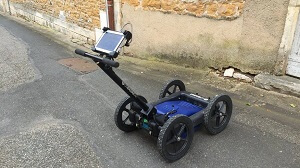
GPR performs best where electromagnetic energy can travel through the subsurface without being heavily attenuated.
Generally favorable conditions include:
- Dry sand
- Dry gravel
- Many rocks
- Concrete
- Asphalt
- Ice
Difficult conditions include:
- Wet clay
- Saline soil
- Salt water
- Highly conductive fill
- Some mineralized soils
The EPA specifically warns that saturated clay and saline water can reduce useful penetration to extremely shallow depths.
The old requirement for soil conductivity below a precise value such as 10-7 S/m is therefore not a sensible universal buying criterion.
GPR success is site-specific.
Training Cost
Buying the equipment does not automatically mean an employee can interpret the data reliably.
Current formal training examples include a one-day NULCA-accredited utility GPR course for $350.
More intensive hands-on instruction can cost substantially more. A current two-day professional GPR course is advertised at approximately $1,350 to $1,395 per person.
Training typically covers:
- Radar principles
- Frequency selection
- Survey design
- Utility signatures
- Hyperbola interpretation
- Depth calibration
- Grid surveys
- Field practice
An experienced operator can also recognize situations where the GPR result is ambiguous and another locating method is needed.
GPR vs Utility-Locating Tool
GPR has one important advantage over ordinary electromagnetic locating: it can potentially detect both conductive and nonconductive objects.
That makes it useful for plastic, concrete, clay, and other utilities that may be difficult to trace electromagnetically.
But GPR does not guarantee identification of everything below the surface.
For utility locating, professionals commonly combine:
- GPR
- Electromagnetic locating
- Utility records
- Surface features
- Vacuum excavation/potholing
- Survey/GPS data
The goal is confidence through multiple sources of evidence rather than treating one radar response as absolute proof.
Archaeology and Cemetery Surveys
GPR is particularly useful where excavation should be minimized.
Archaeologists use it to look for foundations, graves, walls, pits, floors, voids, and changes in stratigraphy.
Cemetery surveys use similar principles to identify potential grave shafts and other subsurface disturbances.
However, radar does not automatically tell the operator, “this reflection is a grave.”
Interpretation depends on pattern, context, site conditions, grid coverage, and supporting evidence.
That is one reason advanced post-processing and experienced interpretation can be worth more than simply purchasing a machine with the greatest advertised depth.
Concrete Scanning
Concrete GPR should not be priced or specified exactly like underground utility equipment.
A concrete scanner is commonly used to locate:
- Rebar
- Post-tension cables
- Electrical conduit
- Voids
- Slab thickness
Because these targets are relatively shallow and fine detail matters, concrete scanners often operate at much higher frequencies.
GSSI’s StructureScan Mini XT, for example, uses a 2.7 GHz antenna and has a stated maximum depth of about 24 inches.
That system architecture would be inappropriate as a direct substitute for a deep geophysical radar.
Example Ownership Cost
Suppose a utility contractor purchases a professional system for:
- GPR system: $20,000
- Advanced software/GPS: $3,000
- Training for two employees: $2,700
- Cases/accessories/spares: $1,000
Initial investment:
$20,000 + $3,000 + $2,700 + $1,000 = $26,700.
At an assumed wage of $30 per hour:
$26,700 ÷ $30 = 890 hours.
That equals roughly 22 full 40-hour workweeks of earnings before taxes.
If professional surveys otherwise cost $2,000 each, the equipment would need to displace roughly:
$26,700 ÷ $2,000 = 13.35 surveys
before the purchase cost alone is recovered.
That calculation ignores labor, insurance, repairs, calibration, transportation, software renewals, interpretation time, and equipment depreciation.
Buy, Rent, or Hire?
Buy when the system will be used regularly and you can justify training operators and maintaining the equipment.
Rent when your team already knows how to use GPR but only needs it occasionally.
Hire a specialist when the survey is infrequent, technically difficult, legally important, or requires a formal report.
For a contractor performing one GPR job every year or two, ownership usually makes little financial sense.
For a utility locating company scanning several sites every week, buying can be much cheaper over time.
What We Verified
- New equipment: current professional guidance places entry-level new systems around $14,000, with many better-equipped units around $25,000 to $35,000.
- Current dealer example: a GSSI UtilityScan Pro package is currently listed at approximately $14,500.
- Advanced systems: modern multi-channel 3D GPR can exceed $100,000.
- Used pricing: current professional-system examples range from approximately $4,500 to $13,000.
- Rental: current cart-based GPR rentals run about $165 to $380 per day, often with additional preparation or mobilization charges.
- Survey services: current 2026 industry analysis puts many professional jobs around $1,000 to $5,000 per field day.
- Computer/software claim corrected: many modern units include an integrated display or tablet and basic acquisition software.
- Antenna claim corrected: GPR systems can use single-, dual-, triple-frequency, or multi-channel configurations; buyers do not universally need “at least two antennas.”
- Frequency claim corrected: useful GPR frequencies extend well beyond 200–1,000 MHz, with high-frequency concrete systems operating above 2 GHz.
- Depth claim corrected: useful penetration is controlled strongly by material conductivity, moisture, frequency, and target characteristics rather than a single advertised maximum.
- Training: current courses range from approximately $350 for one-day utility-locating instruction to about $1,350+ for intensive multi-day training.
Answers to Common Questions
How much does ground penetrating radar cost?
Most new professional single-channel systems cost approximately $14,000 to $35,000. Advanced 3D and multi-channel systems can exceed $100,000.
How much does a used GPR cost?
Current used professional systems commonly run around $4,500 to $13,000, depending on age, antenna, software, calibration, and accessories.
How much does it cost to rent GPR?
Common cart systems currently rent for roughly $165 to $380 per day, before preparation, mobilization, shipping, or insurance charges.
How much does a GPR survey cost?
Professional survey work commonly costs around $1,000 to $5,000 per day. Small concrete scans or utility locates may be priced by minimum callout, hour, area, or project rather than day.
Disclosure: Educational content, not financial advice. Prices reflect public information as of the dates cited and can change. Confirm current rates, fees, taxes, and terms with official sources before purchasing. See our methodology and corrections policy.