
How Much Does Private Utility Locating Cost?
Last Updated on March 5, 2024
Written by CPA Alec Pow | Content Reviewed by ![]() CFA Alexander Popinker
CFA Alexander Popinker
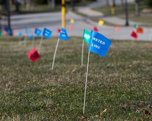
When you are digging, you need a private utility locator’s service to identify buried utilities. So, you are able to avoid mistakes that would cost you a lot of money, like digging too close to an electrical line that may affect your property’s structure or not having enough space between a gas line and your building.
The main tool used for locating utilities underground is the Ground Penetrating Radar (GPR). This can help you to find any type of subsurface utility such as buried fiber optic cables, electrical wires, storm drains, gas lines, sewer and water pipes, and many others.
How Much Does Private Utility Locating Cost?
You should plan on spending around $255 per hour for locating utilities with a Ground Penetrating Radar. However, the price for private utility locating services varies depending on how much land you have to scan. Retainer packages are offered for municipalities, and this helps to save money in the long run.
A minimum of forty hours are required per year for municipality retainers, and this is why it is recommended to include this service in their annual budget.
Why should I hire a private utility locator company?
If you know exactly where the public utilities are buried you can avoid mistakes that could seriously harm, or even end someone’s life.
A private underground utility locating company can:
- help you to avoid dangerous and costly digging mistakes and save on your project’s budget and timeline;
- map with precision the location of underground utility lines in an easy-to-understand AutoCAD rendering;
- locate a various range of utility lines including sewage, water, communications, gas, power, and more.
Ground Penetrating Radar overview
 Ground-penetrating radar is a form of geophysics that uses electromagnetic wave pulses with frequencies between 50 MHz and 2.5 GHz to detect the subsurface.
You might also like our articles about the cost of GPRs, metal detectors, and the most expensive metals.
It is a non-intrusive method of surface surveillance to investigate underground utilities such as concrete, asphalt, metals, pipes, cables, or masonry.
In archeology, it is useful for identifying hidden structures. The GPR method is one of the most complete and correct investigation methods used by archaeologists, improving over time and providing more and more detailed information on structural features buried in the ground, also relieving them of a huge amount of work that should have been done through the classical methods of archaeological investigation.
In some cases, the ground-penetrating radar cannot be used and it is necessary to know the limits.
Things to remember when working with a GPR:
- Recording signals contain a lot of information.
- Even experts can make mistakes in interpreting the results.
- The actual operating conditions are very different from the ideal (model) conditions, on which the operation of the device is checked.
- The interpretation of survey control results depends on the context (the same image can be interpreted in different ways, depending on the place, the study environment, etc.)
What is the working principle of GPR and utility locate services?
The GPR emits an electromagnetic signal by means of a radio wave. GPR allows investigating the structure of the pedological substratum and underground facilities, without interfering with them. Thanks to the method, prospecting becomes more efficient from an economic and time point of view, bringing an obvious advantage over the classic technology based on installments.
This method is based on the property of waves to reflect from different obstacles, depending on their electromagnetic characteristics. A typical system is composed of a data recording unit and two antennas, one low frequency and one high frequency, representing a transmitter and a receiver.
The transmitter emits electromagnetic pulses that are reflected and detected by the receiver according to the characteristics of the explored environment. The maximum penetration depth of the propagating wave depends on the wavelength of the radiation used and the dielectric constant of the investigated medium.
Important things about private locating services
When working on projects that involve excavation, it is required by law to call the 811 hotline.
Before any type of excavation can take place, utility companies, public and private, are required by law to mark utility lines. However, city planners, business owners, and homeowners are left with very little information about what is buried below their land when private utilities like gas line extensions or irrigation systems are not marked on the property survey map.

Leave a Reply
Want to join the discussion?Feel free to contribute!